
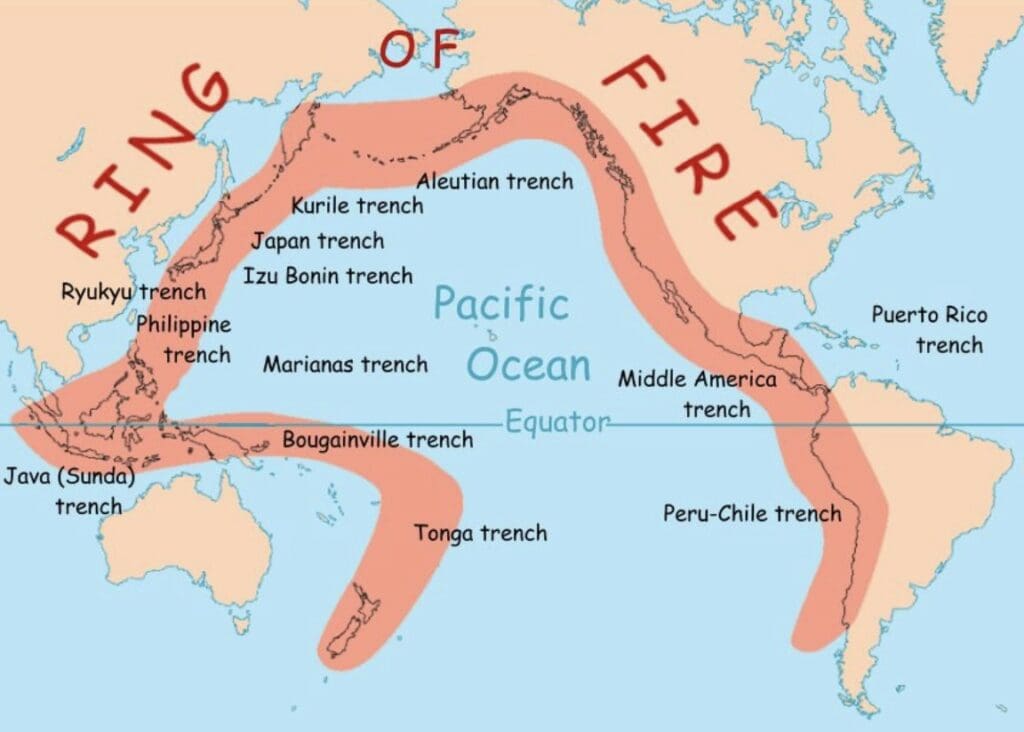
BACKGROUND: On July 30, 2025, at 11:24AM PETT, a magnitude 8.8 megathrust earthquake struck off the eastern coast of Russia’s Kamchatka Peninsula. The region lies within the Pacific Ring of Fire, a zone known for intense seismic and volcanic activity. Roughly 90% of the world’s earthquakes and 75% of its active volcanoes are along this ring. This particular earthquake originated in the Kuril-Kamchatka subduction zone, where the Pacific Plate is forced beneath the North American Plate, ranking among the top six most powerful seismic events recorded globally.
Tsunami waves of 3-5 meters struck Severo‑Kurilsk on the Kuril Islands. Tsunami warnings were issued in Japan, Hawaii, the U.S. West Coast, French Polynesia, the Kingdom of Tonga, Chile, Ecuador, and even as far south as the Galápagos Islands. Warnings were later downgraded in most regions as waves proved less damaging than initially feared. In this post, we will detail the timeline and decision-making process we experienced during this event on our sailboat in Tonga.
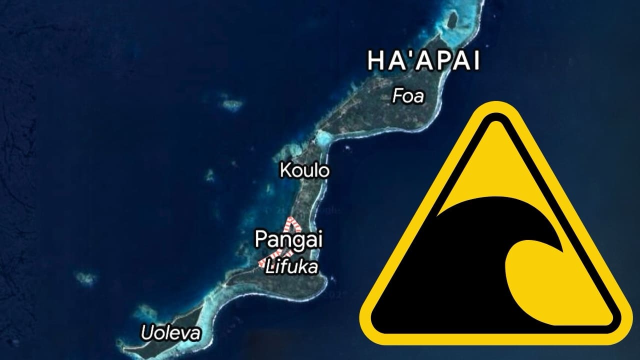
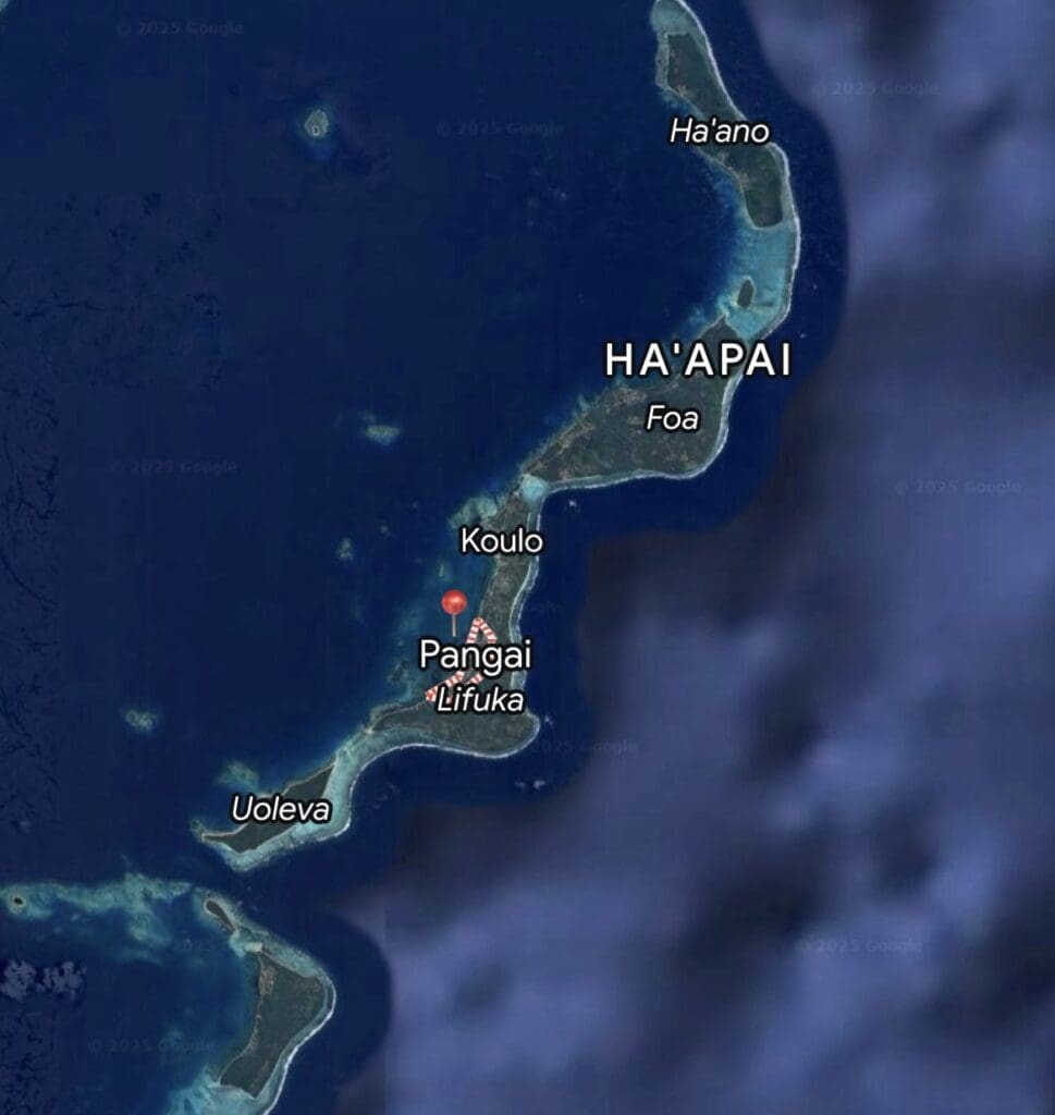
JULY 30, 2025 12:43PM: Our first tsunami alert came via WhatsApp from Viki, the coordinator of the Pacific Rally. We had hastily registered for the rally last year when we thought we’d be making a last-minute dash to New Zealand before cyclone season and needed help navigating the paperwork, check-in, and visa process because we hadn’t had time to research it thoroughly ourselves. When those plans fell through, Viki kindly carried our registration over to this year, and the rally has been an excellent resource for us. We were anchored in Pangai in about 5m of water at the time, with 25–30 knots of wind blowing through the anchorage. The forecast for the next 24 hours looked gnarly, with the wind set to clock around from the West, leaving us with zero protection. We’d planned to hunker down and ride it out.
After receiving the alert, our first instinct was to turn to social media. Is this real? What is everyone else doing? Is the threat serious enough to leave our anchorage in these conditions? Then we went to Google. When do tsunami sirens go off? How much warning do you get? How far does the water usually recede, and is the recession proportional to wave height? We quickly realized that we didn’t know much about tsunamis.
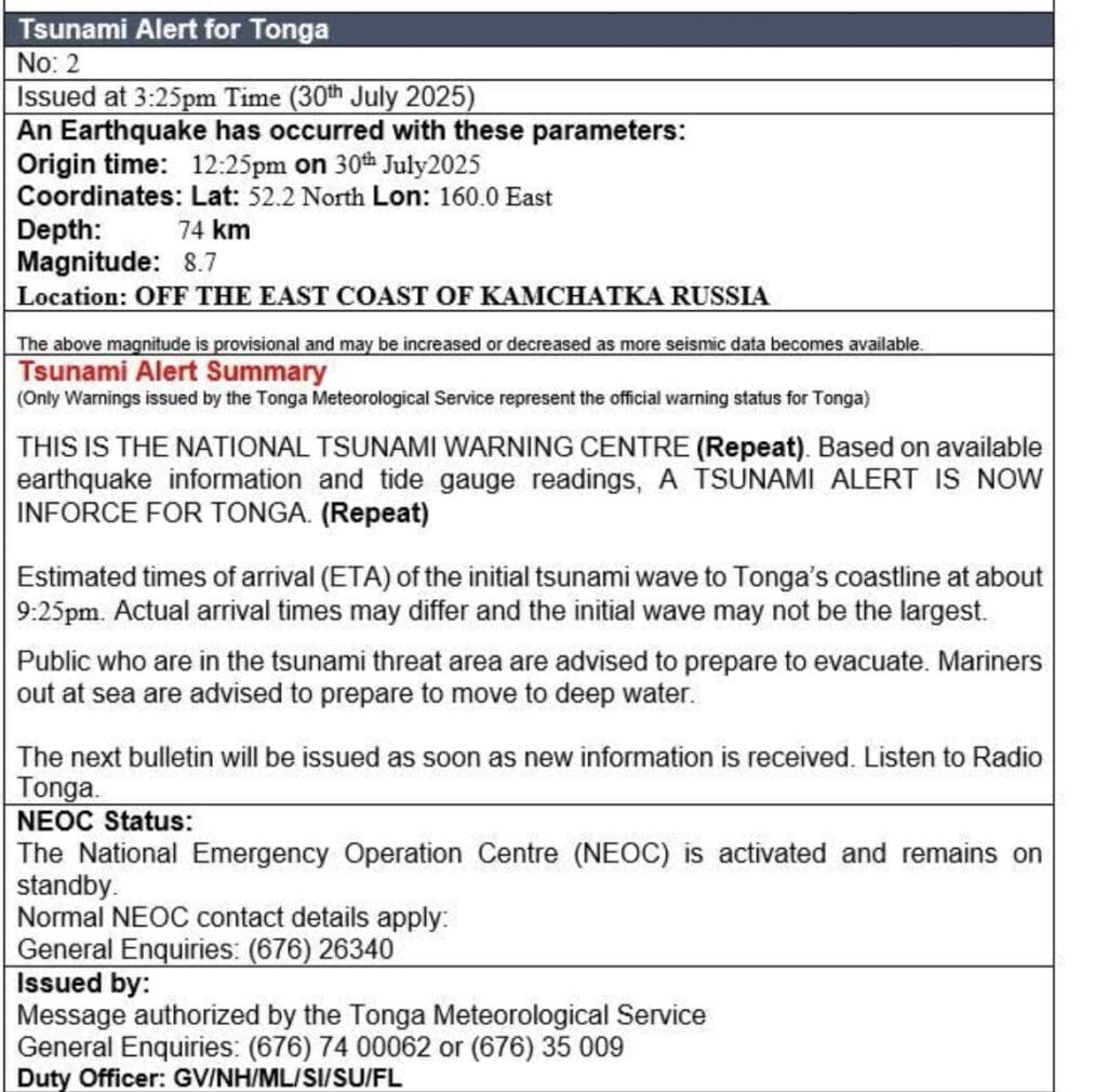
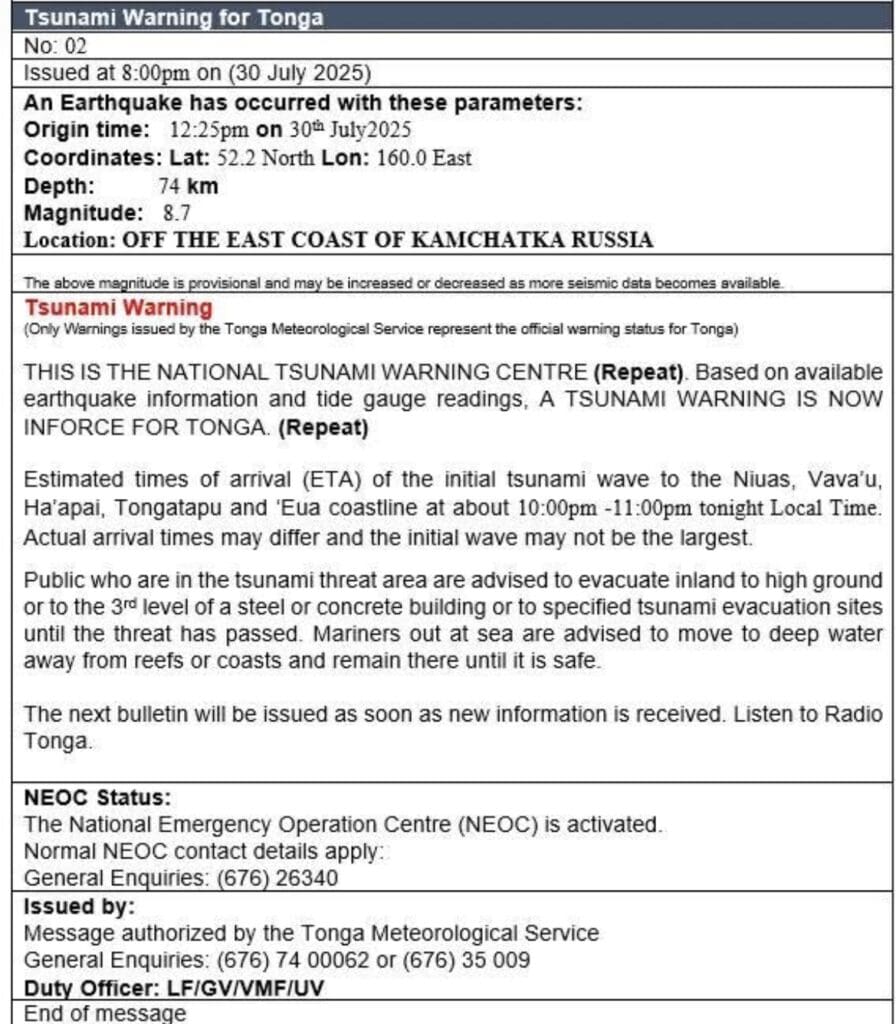
JULY 30, 2025 3:25PM: The Government of Tonga posted an official bulletin, putting us on “Tsunami Alert”. We only saw this because we were actively searching for it.
Tsunami warning systems use different levels to communicate the risk and urgency of a potential tsunami. The specific terminology can vary slightly by region or country, but the most commonly used levels are:
- Tsunami Watch: A tsunami is possible, but not yet confirmed, issued soon after a large undersea earthquake. Threat level = Uncertain. It’s too early to tell if a tsunami will occur.
- Tsunami Advisory/Alert: A potential tsunami may produce strong currents or dangerous waves, especially in harbors and coastal areas. Threat level = Low to moderate. Flooding is not expected, but marine and beach conditions can be dangerous.
- Tsunami Warning: A tsunami is imminent or already occurring and poses a significant threat to life and property. Threat level = High. This is the most serious level.
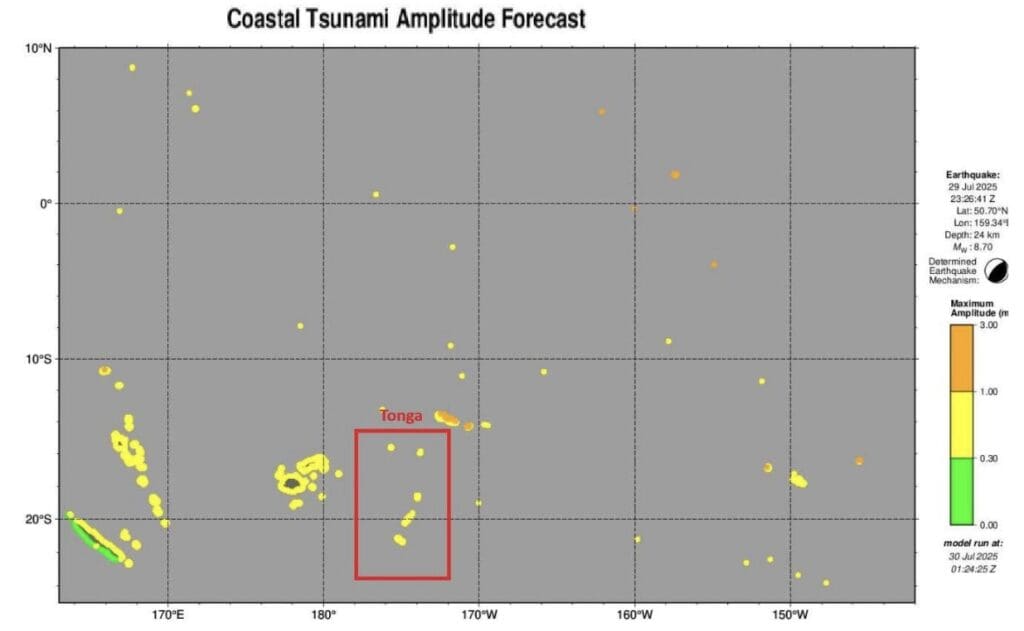
We began preparing the boat to move: we secured the dinghy, checked both engines, closed all hatches, gathered our emergency and foul-weather gear, planned our route, and alerted our family of our situation/location/plan in writing (this can be helpful if you have to file an insurance claim later). At this point, the tsunami was projected to be anywhere from 0.5 to 3m, which could potentially put us on dry land. We were seeing reports of boats being kicked out of marinas and harbors, forced to head out to sea. Taking the official recommendation seriously, we decided to move to deeper water. The first wave was estimated to arrive at 9:25PM.
We went back and forth on our departure time: we’d like to minimize the time we spend being thrashed around in high winds and waves, but were wary of leaving the reef-ridden shoreline in the dark. We wondered how accurate these wave arrival time estimates are. How far ahead of the wave might the water recede? I felt a bit jealous of folks in more populated anchorages sharing information and bouncing ideas off one another. There can be comfort in numbers. We needed to remain calm, do our research, and make the best decision for us and our vessel.
We chose to pull our anchor at 5pm, giving us enough daylight to navigate the reefs before reaching a depth of 1000ft+, several miles away from our anchorage, where we would drift until the threat passed. Tsunami waves only build height and force when they reach shallow coastal areas (the seafloor causes the wave to slow and grow taller). So, tsunamis in deep water are barely noticeable, and boats will rise and fall gently with the wave.
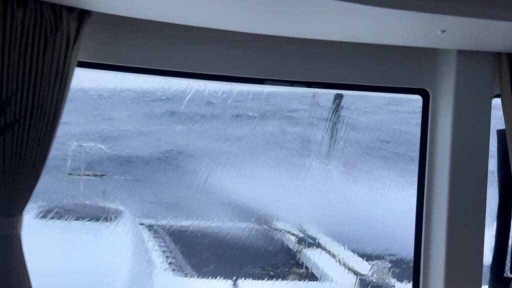
Conditions were miserable. We were in full foul-weather gear, cold and soaking wet as we were pelted by rain and salt spray.
It’s also whale season here in Tonga, adding another layer of difficulty to our plan: don’t hit a whale. It may sound crazy, but it happens. Collisions are actually the leading cause of death for large whale species like humpback, blue, and sperm whales, and can cause detrimental damage to boats like ours. We kept our speed low and maintained an active watch to lower our risk of collision.
JULY 30, 2025 8PM: Sirens began sounding on shore as Tonga was upgraded from a “Tsunami Alert” to a “Tsunami Warning.” At that point, all amplitude forecasts predicted the wave to be 1 meter or less.
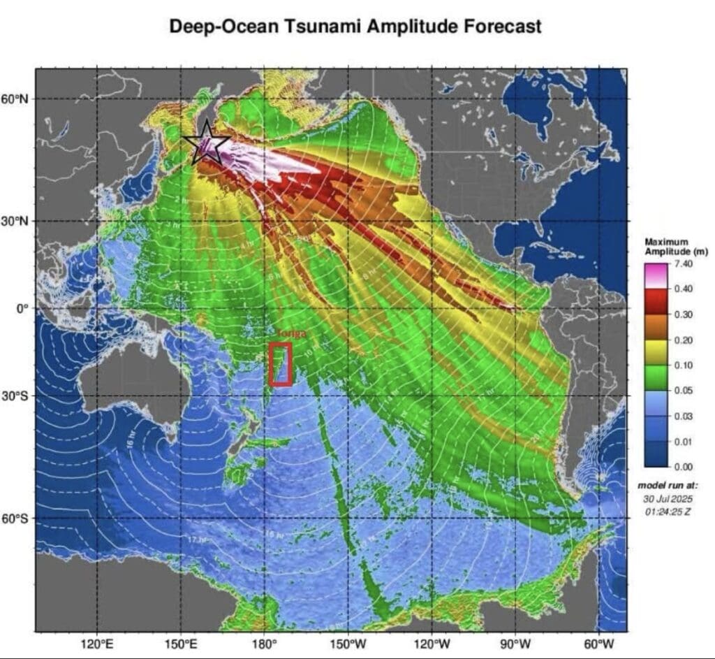
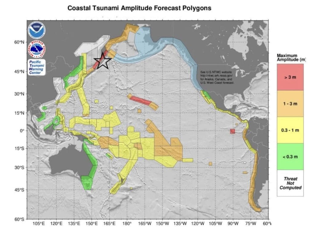
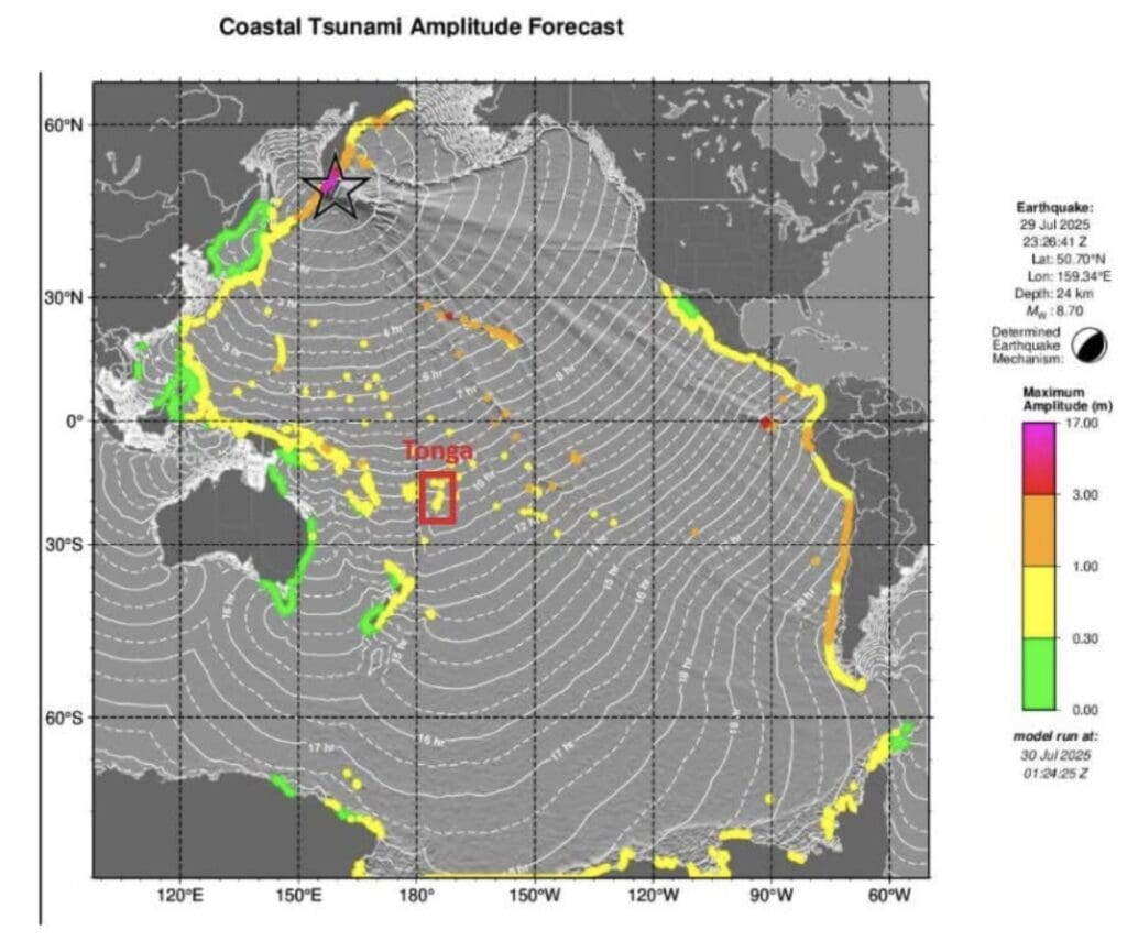
Neither of us had ever seen a tsunami amplitude forecast before. Here’s what we’ve learned:
- Amplitude ≠ Wave Height. Amplitude is half of the full wave height, because tsunami waves are measured from the middle of the wave (still water level) to the peak or trough. So, if the graph shows +0.5m amplitude, the peak-to-trough wave height is ~1m.
- Tsunamis arrive as a series of waves, not just one. The first wave is not always the largest; subsequent waves may be stronger.
- These graphs may not capture local amplification effects in harbors and bays, or wave reflections and resonance.
These amplitude forecasts gave many people a false sense of security. Even a small tsunami wave can pose serious dangers. Here is a breakdown of potential hazards:
- The distance of water drawback before a tsunami can be surprisingly large, depending on the slope and shape of the seafloor near the coast. For a 1 meter tsunami, the water can recede anywhere from a few meters to a kilometer from the normal shoreline. This is because tsunamis are long-wavelength waves (up to hundreds of kilometers long). As a trough approaches, it “sucks” water away from shore, exposing the seafloor. The flatter the slope, the farther the water pulls back.
- Tsunamis are not like regular surf waves. The entire water column is moving, not just the surface. Force = mass × acceleration. Even a small tsunami wave has a huge mass. So, even a small wave can come in like a fast-moving flood or surge, reaching speeds of 30–50 km/h or more.
- As the water surges inland, debris such as logs, building materials, cars, etc., might be dragged back out to sea. The debris could become high-speed projectiles, capable of causing severe injury or damage to your vessel.
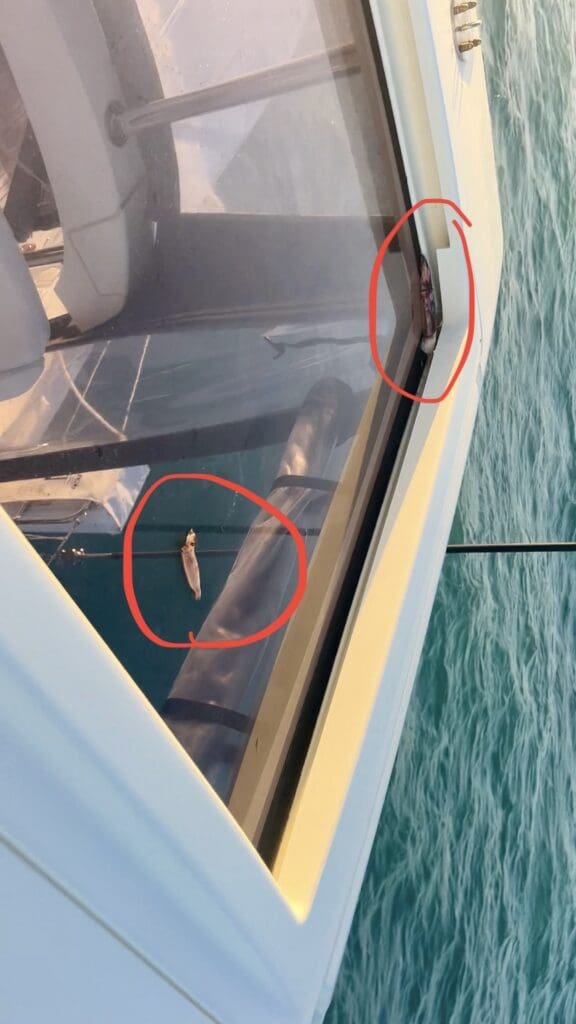
Given the information we had at the time and the topography of our anchorage, we were satisfied with our decision despite how uncomfortable we were in the wind and waves. We turned the engines off and drifted, periodically firing them back up to redirect when we began moving toward a reef. Waves crashed into our cockpit and across our deck, sending flying fish to our doorstep and catching squid on our roof. These conditions were weather-related, not tsunami-related.

JULY 30, 2025, 9:30PM: We did not experience a wave event during the tsunami ETA. However, we did experience some unusual currents, pushing and pulling our boat in different directions for several hours. Others who opted to stay in deep anchorages/mooring fields reported seeing a depth rise and fall of a couple meters. We were grateful it ended up being uneventful.
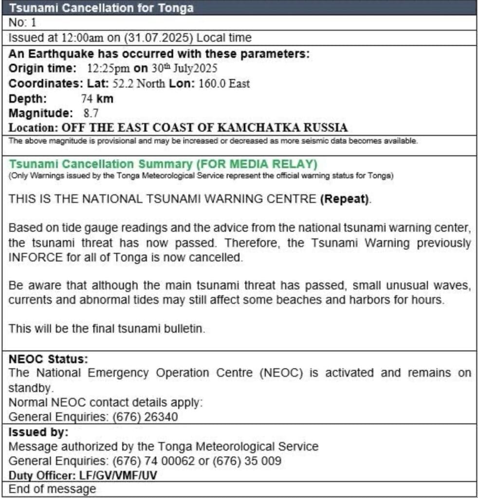
JULY 31, 2025 12:00AM: The Tsunami warning was officially cancelled, and we followed our tracks back to our anchorage, still experiencing strong swirling currents. We safely re-anchored and rode out the rest of the storm as planned.
CONCLUSION: Despite being one of the most powerful earthquakes in recent memory and triggering tsunami waves up to 4m locally, there were no recorded deaths. This outcome was widely credited to robust early warning systems, fast and coordinated evacuations, and fortunate circumstances such as low population density near the epicenter. For us, timing and connectivity were key. Having a few hours to prepare the boat, do some research, and ultimately devise and execute a well-thought-out plan was essential.
We have begun wondering: What would’ve happened if this occurred at night, when we typically silence our cell phones? What if we had turned Starlink off for the night? Would we have heard the sirens in our anchorage over the wind and waves? We are eager to find a suitable alert system for the future. This is what we’ve discovered so far:
- Disaster Alert: a free mobile and web-based resource developed by the Pacific Disaster Center (PDC Global). It’s designed to provide early warnings and updates on natural hazards worldwide, including earthquakes, tropical cyclones (hurricanes/typhoons), tsunamis, volcanoes, floods, wildfires, and tornadoes. We found the sign-up process glitchy and the customization options for alerts and location radius sub-optimal for boating.
- Quake Alerts: an iOS-only app offering a 7-day free trial, then charging $2.99 annually. The setup was straightforward and more user-friendly than Disaster Alert, and I like that you can customize the magnitude for which you will receive an alert. There are ads when you click to see more contextual info about a warning, even if you pay the $2.99.
- Smart Traveller Enrollment Program (STEP): STEP is free for US citizens travelling abroad. It sends email alerts for natural disasters, health, and security events. However, you have to manually update what country you’re in; it does not track your location.
We haven’t found a solution that fully meets our needs, so Ray is designing a custom system to keep us informed. It will cover not only natural disasters but also civil and geopolitical unrest that may influence our cruising decisions. Our goal is to receive a standard daily report along with real-time emergency alerts when necessary. Here’s an example of what a daily report might look like:
“As of August 3, 2025 (next 4 days): Weather in Vava’u, Tonga—highs 23-26°C (73-79°F), partly cloudy with light SE winds (10-19 mph) and low to moderate chance of showers; stable marine conditions. No major natural disasters: no active earthquakes, tsunamis (Kamchatka alerts cancelled, no ongoing threats), or volcanic activity in Tonga; minor regional events include M5.0 and M4.4 earthquakes in Papua New Guinea on Aug 2 with no impact. World events stable, with regional Pacific forums and sports but no disruptions. Geopolitical tensions elevated (US-China rivalry amid tariff negotiations, Russia-Ukraine war with accelerating Russian advances and drone strikes, escalating trade tariffs on multiple countries); includes US repositioning 2 nuclear subs in response to Russian threats. Unlikely to impact South Pacific sailboat activities. Safe sailing; monitor updates.”
He’s teamed up with other tech enthusiasts to bring this idea to life, and we’ll share more details as we begin testing it. While we hope this was a once-in-a-lifetime experience, it revealed a blind spot in our knowledge and preparedness that we’re determined to address!
4 Responses
Hi Sabado,
Definitely a scary time figuring out the Tsunami. Great research on your part. We were in Neiafu on a mooring that night and had metup with some other cruisers for pizza at Mangos. It was definitely the topic for discussion. Too bad we missed you again becasue on Saturday with a decent weather window we left for Fiji. We should arrive at Nawi Island Marina early tomorrow. https://nawiisland.com/ .
BTW if you want a beta tester for the alert system I am interested and will definitely provide feedback.
All the best
Fred
Dang, we keep missing each other! We hope you are having a safe passage. Our shallow anchorage and stormy weather definitely complicated things… we would’ve preferred to be in Neiafu! We’ll keep you in the loop about this alert system. Thanks for your support! ❤️
my heart was racing while reading! that is very scary stuff guys!
your teamwork is amazing as always! lots of love!
It could have been much worse! Thankful we had so much notice to prepare. 🙏🏼